User Center
 My Training Class
 Feedback


Knowledge application (知识应用)
IKCEST Solutions to SDG 4: Quality Education(支撑SDG 4优质教育)
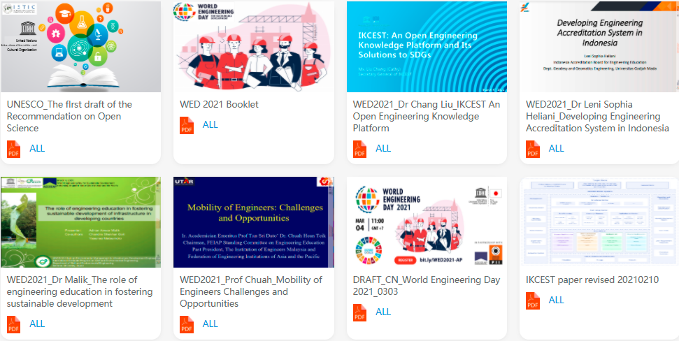
Introduction: The knowledge application IKCEST Solutions to SDGs, with one of its specific focuses on SDG 4: Quality Education, pools online video education resources from IKCEST's sub-platforms, academic conference videos, and academic presentation slides.
Recently, conference materials of Inputs from Asia-Pacific region to the UNESCO Recommendation on Open Science, Asia-Pacific Online Regional Consultation have been added, including the draft recommendation, summary of the global survey on Open Science, presentation handout and more. In addition, related documents of the online commemoration of the 2021 World Engineering Day, such as the presentation materials and meeting booklet, have been included in the knowledge application. The materials are added to provide online learning services for professionals and students in the education field in developing countries, promote quality education and support achieving the 2030 Agenda for Sustainable Development.
Source: IKCEST General Platform
Release date: Apr. 2021
Provided by: Cai Lingli, Zhang Xinxing, Guo Yifei
Video (视频课件)
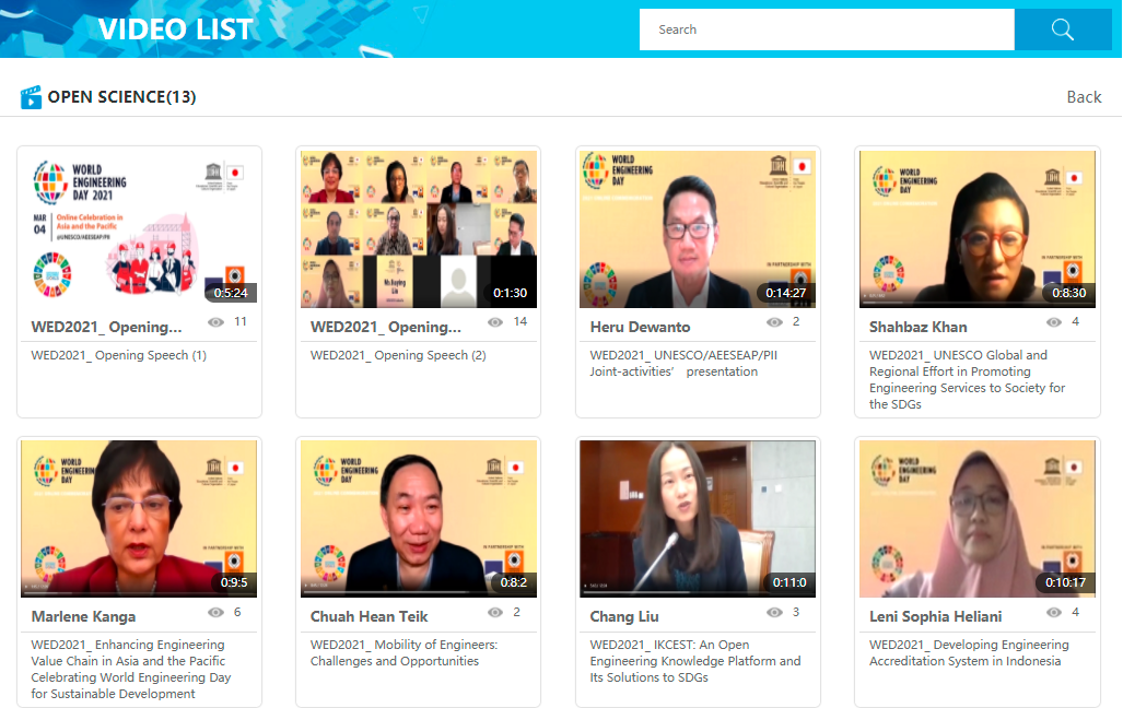
Open Science(开放科学视频栏目)
Introduction: Open Science is the movement to make scientific research and data accessible to all. Its many advantages include greater availability and accessibility of publicly funded scientific research outputs, possibility for rigorous peer-review processes, greater reproducibility and transparency of scientific works and greater impact of scientific research.
A new column, Open Science, will be added to the Videos section of IKCEST in addition to existing video resources of academic conferences and They Say, to present videos of discussions on Open Science in the Asia-Pacific region.
You can learn about the regional landscape, key challenges and needs in professional competence development for sustainable development and recommendations to overcome them, and prospects for international collaboration and networking to advance a global platform for engineers here in this video column.
Source: IKCEST General Platform
Release date: Apr. 2021
Provided by: Cai Lingli, Zhang Xinxing, Guo Yifei
Scientific Data (科学数据)
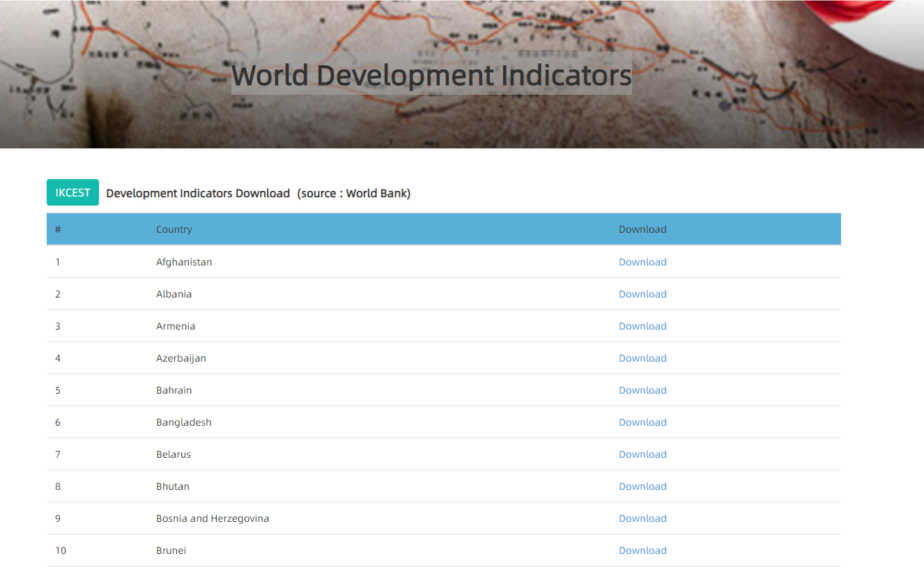
World Development Indicators- Belarus(世界发展指标-白俄罗斯)
Introduction: It contains 55 data items from Bangladesh with a time span of 50 years (1968-2017) and supports visual display of data, including line, bar, scatter, and pie charts of indicators. It provides all information export functions. The data could be downloaded in Chinese, English, Russian and Arabic.
Source: Silk Road Sciences and Technology Knowledge Service
Release date: Apr. 2021
Provided by: Dong Yang
Knowledge application (知识应用)
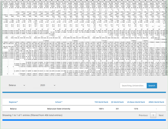
The World Rank of Pakistan University(“一带一路”高校排名-白俄罗斯)
Introduction: A knowledge application for comprehensive display and inquiry of Pakistan University is built to comprehensively display four internationally recognized world university rankings, such as QS, THE, US News and ARWU rankings, so as to facilitate engineering and scientific personnel from countries along the "Belt and Road" to recruit students in countries along the "Belt and Road".
Source: Silk Road Sciences and Technology Knowledge Service
Release date: Apr. 2021
Provided by: Zhang Qianglong
Video (视频课件)
China's Opening——A Historical View(中国对外开放的历史考察)
Introduction: By brief yet thorough introduction about China's communication with the outside world, the course aims to provide the students a wholistic understanding about China's opening to the outside world during the past five years. Though different periods of China's communication with the outside world carry different characteristics, the core cultural value that goes through the history of China's communication with the outside world is its cherishing of "harmonious coexistence with its neighbors the world". This course will also make a brief introduction about the formation of different periods in China so that the students can better understand the characteristics of China's communication with the outside world.
Source: Silk Road Sciences and Technology Knowledge Service
Release date: Apr. 2021
Provided by: Liu Jun
Scientific Data (科学数据)
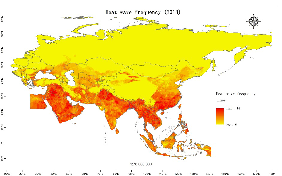
Historical meteorological space mapping in the Belt and Road (一带一路地区历史气象空间制图)
Introduction: The daily apparent temperature was calculated based on the data of daily meteorological stations, and the apparent temperature raster data set of the Belt and Road region was obtained by using the interpolation method based on elevation correction, the high temperature heatwave data set of this region was calculated based on the combined heat wave threshold (CHWT) method. This data set shows the temporal and spatial distribution of high temperature heat waves in the Belt and Road region, which provides a reference and basis for users and further research.
Source: Disaster Risk Reduction Knowledge Service
Release date: Oct. 2020
Provided by: Yuan Yuelei
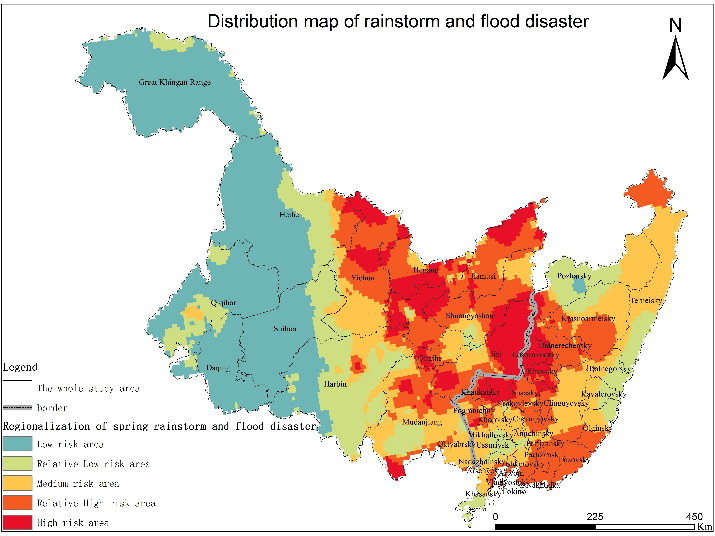
The distribution of rainstorm-flood disaster risk in the cross-border area between China and Russia(中俄毗邻地区暴雨洪涝风险分布数据集)
Introduction: This dataset described the distribution of rainstorm-flood disasters in countries between China and Russia during 1980 to 2016, which mainly record the specific location, risk grade, and range information. They were collected and organized by the Institute of Geographic Sciences and Natural Resources Research, Chinese Academy of Sciences. This dataset was composed of raster files. They could be used to study the occurrence and distribution of meteorological disasters, and provided an important basis for preventing the disasters and reducing the negative impact of the disasters.
Source: Disaster Risk Reduction Knowledge Service
Release date: Jan. 2021
Provided by: Yuan Yuelei
Knowledge application (知识应用)
Knowledge Map Service of Major Organization for Disaster Risk Reduction(防灾减灾组织机构地图服务知识应用)
Introduction: To meet the requirements of organization catalogue for disaster risk reduction, the management and visualization function modules are developed to support the organization directory navigation. The visualization application of data and maps have been realized by WebGIS technology, including "Map View" mode and "Data View" mode.
Source: Disaster Risk Reduction Knowledge Service
Release date: 2017
Provided by: Yuan Yuelei
Video (视频课件)
Spatiotemporal analysis of public response to COVID-19 based on social media data(基于社交媒体的公众对COVID-19反应的时空分析)
Introduction: The outbreak of Corona Virus Disease 2019 (COVID-19) is a grave global public health emergency. Nowadays, social media has become the main channel through which the public can obtain information and express their opinions and feelings. This study explored public opinion in the early stages of COVID-19 in China by analyzing Sina-Weibo (a Twitter-like microblogging system in China) texts in terms of space, time, and content. Temporal changes within one-hour intervals and the spatial distribution of COVID-19-related Weibo texts were analyzed. Based on the latent Dirichlet allocation model and the random forest algorithm, a topic extraction and classification model was developed to hierarchically identify seven COVID-19-relevant topics and 13 sub-topics from Weibo texts. The first step was to mine and generalize the topics from the COVID-19-related Weibo sample using the LDA model. Then, topic extraction results were utilized as training samples for the RF algorithm to classify the Weibo data. The results indicate that the number of Weibo texts varied over time for different topics and sub-topics corresponding with the different developmental stages of the event. The spatial distribution of COVID-19-relevant Weibo was mainly concentrated in Wuhan, Beijing-Tianjin-Hebei, the Yangtze River Delta, the Pearl River Delta, and the Chengdu-Chongqing urban agglomeration. There is a synchronization between frequent daily discussions on Weibo and the trend of the COVID-19 outbreak in the real world.
Source: Disaster Risk Reduction Knowledge Service
Release date: 2021
Provided by: Yuan Yuelei
Scientific Data (科学数据)
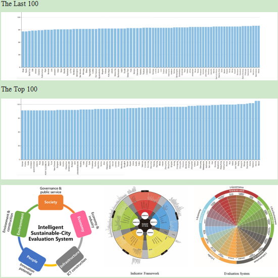
Latest Global CityIQ Ranking(最新全球城市IQ排名)
Introduction: The CityIQ column aims at developing a data model to provide evaluation services for global cities, undertaking sustainable development research tasks, relating to themes of urban planing, transportation, environment, safety and encouraging cities to provide data and best practices to support database construction and to improve the worldwide competences of city database and city evaluation system.
Source: Intelligent City Knowledge Service
Release date: Apr. 2021
Provided by: CAO Buyang
Video (视频课件)
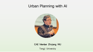
Urban Planning with AI (城市规划与人工智能)
Introduction: CAE Member WU Zhiqiang serves as Co-Chair of International Steering Committee of World Planning School Congress, Permanent Member of UNESCO-UIA (International Union of Architects) , Member of Advisory Committee - Creative Economy-United Nations Special Unit for South-South Cooperation, UNDP, National Master of Engineering Survey and Design.
Source: Intelligent City Knowledge Service
Release date: Mar. 2021
Provided by: LI Xiang
Review of Some Data Analytics Techniques (数据分析技术回顾)
Introduction: Professor Buyang Cao was awarded by INFORMS (Institute for Operations and Management Science) due to excellence in applying optimization techniques for solving complicated decision support problems from the real world. Numerous research papers by Dr. Cao appeared in some top-tier international journals. Currently, his research is focusing on applying big data, data analytical, and algorithm development technologies to the problems from Smart City and Logistics arenas.
Source: Intelligent City Knowledge Service
Release date: Apr. 2021
Provided by: LI Xiang
>>>IKCEST Newsletter 2021 February<<<
>>>IKCEST Newsletter 2020 December<<<